Tennessee Landforms -- arches and natural bridges| WGS84 |
| 35.130130 | -84.593900 |
| 35° 7.808'N | 84° 35.634'W |
| 35° 7' 48.5"N | 84° 35' 38"W |
| 16S 719234E 3890124N |
| convert to NAD27 |
Thornburg Bridge 23x6
Waypoint: POA001 35.130130,-84.593900
County: Polk landforms of Polk county
Locale: Cherokee National Forest
NABSQNO 16S-719234-3890124
popup list of
nearby landforms (mileage, bearing)
MAPS
Select one of the following maps to display this waypoint (WGS84).
GPS
Remarks:
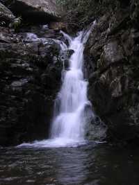
Rock bridge (gravity) with Thornburg Ridge Falls
cutting underneath.
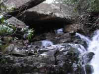
Hike up Scenic Spur Trail then off-trail up the creek.
(see trail maps)
Tennessee landforms
home
arches
waterfalls
rocks
peaks
balds
sinks
lakes
regions
county
GSMNP landforms (TN/NC)
BSF landforms (TN/KY)
or nearby
lookout towers
 ©
Tom Dunigan
©
Tom Dunigan