Tennessee Landforms -- waterfalls| WGS84 |
| 36.327646 | -85.489237 |
| 36° 19.659'N | 85° 29.354'W |
| 36° 19' 39.5"N | 85° 29' 21.2"W |
| 16S 635601E 4021349N |
| convert to NAD27 |
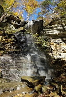
Rainbow Rock Falls 45'
Waypoint: OVF029 36.327646,-85.489237
County: Overton landforms of Overton county
popup list of
nearby landforms (mileage, bearing)
MAPS
Select one of the following maps to display this waypoint (WGS84).
GPS
Remarks:
Reference and photo: Ryan Gardner
Tennessee landforms
home
arches
waterfalls
rocks
peaks
balds
sinks
lakes
regions
county
GSMNP landforms (TN/NC)
BSF landforms (TN/KY)
or nearby
lookout towers
 ©
Tom Dunigan
©
Tom Dunigan