Tennessee Landforms -- arches and natural bridges| WGS84 |
| 36.267000 | -85.165700 |
| 36° 16.02'N | 85° 9.942'W |
| 36° 16' 1.2"N | 85° 9' 56.5"W |
| 16S 664771E 4015124N |
| convert to NAD27 |
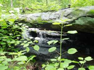
Honey Springs NB 5x2
Waypoint: OVA006 36.267000,-85.165700
County: Overton landforms of Overton county
Locale: private
NABSQNO 16S-664771-4015124
popup list of
nearby landforms (mileage, bearing)
MAPS
Select one of the following maps to display this waypoint (WGS84).
GPS
Remarks:
Tennessee landforms
home
arches
waterfalls
rocks
peaks
balds
sinks
lakes
regions
county
GSMNP landforms (TN/NC)
BSF landforms (TN/KY)
or nearby
lookout towers
 ©
Tom Dunigan
©
Tom Dunigan