Tennessee Landforms -- waterfalls| WGS84 |
| 35.454440 | -83.971940 |
| 35° 27.266'N | 83° 58.316'W |
| 35° 27' 16"N | 83° 58' 19"W |
| 17S 230274E 3927500N |
| convert to NAD27 |
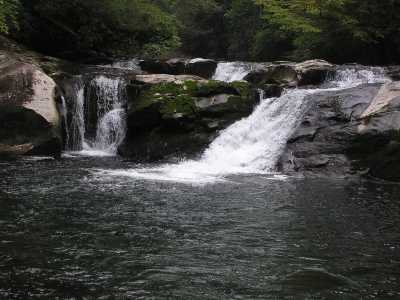
Lower Falls 15'
Waypoint: MOF009 35.454440,-83.971940
County: Monroe landforms of Monroe county
Locale: Cherokee National Forest
popup list of
nearby landforms (mileage, bearing)
MAPS
Select one of the following maps to display this waypoint (WGS84).
GPS
Remarks:
CNF trail 42. Slickrock Creek is the border between NC and TN.
Tennessee landforms
home
arches
waterfalls
rocks
peaks
balds
sinks
lakes
regions
county
GSMNP landforms (TN/NC)
BSF landforms (TN/KY)
or nearby
lookout towers
 ©
Tom Dunigan
©
Tom Dunigan