Tennessee Landforms -- rock formations| WGS84 |
| 36.059700 | -84.791400 |
| 36° 3.582'N | 84° 47.484'W |
| 36° 3' 34.9"N | 84° 47' 29"W |
| 16S 698921E 3992827N |
| convert to NAD27 |
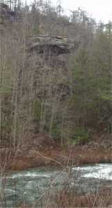
Devil's Breakfast Table 40'
Waypoint: MGR002 36.059700,-84.791400
County: Morgan landforms of Morgan county
Locale: CT OWSR Catoosa
popup list of
nearby landforms (mileage, bearing)
MAPS
Select one of the following maps to display this waypoint (WGS84).
GPS
Remarks:
Tennessee landforms
home
arches
waterfalls
rocks
peaks
balds
sinks
lakes
regions
county
GSMNP landforms (TN/NC)
BSF landforms (TN/KY)
or nearby
lookout towers
 ©
Tom Dunigan
©
Tom Dunigan