Tennessee Landforms -- waterfalls| WGS84 |
| 36.044939 | -84.719567 |
| 36° 2.696'N | 84° 43.174'W |
| 36° 2' 41.8"N | 84° 43' 10.4"W |
| 16S 705430E 3991339N |
| convert to NAD27 |
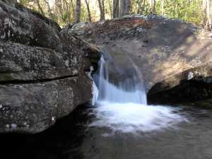
Island Creek Falls 9'
Waypoint: MGF018 36.044939,-84.719567
County: Morgan landforms of Morgan county
Locale: Catoosa
popup list of
nearby landforms (mileage, bearing)
MAPS
Select one of the following maps to display this waypoint (WGS84).
GPS
Remarks:
Tennessee landforms
home
arches
waterfalls
rocks
peaks
balds
sinks
lakes
regions
county
GSMNP landforms (TN/NC)
BSF landforms (TN/KY)
or nearby
lookout towers
 ©
Tom Dunigan
©
Tom Dunigan