Tennessee Landforms -- waterfalls| WGS84 |
| 36.021692 | -84.585421 |
| 36° 1.302'N | 84° 35.125'W |
| 36° 1' 18.1"N | 84° 35' 7.5"W |
| 16S 717581E 3989052N |
| convert to NAD27 |
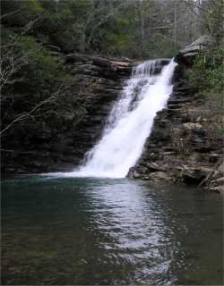
Mill Creek Falls 30'
Waypoint: MGF016 36.021692,-84.585421
County: Morgan landforms of Morgan county
Locale: private
popup list of
nearby landforms (mileage, bearing)
MAPS
Select one of the following maps to display this waypoint (WGS84).
GPS
Remarks:
Reference: Kevin Baker
see
whitewater info
Tennessee landforms
home
arches
waterfalls
rocks
peaks
balds
sinks
lakes
regions
county
GSMNP landforms (TN/NC)
BSF landforms (TN/KY)
or nearby
lookout towers
 ©
Tom Dunigan
©
Tom Dunigan