Tennessee Landforms -- waterfalls| WGS84 |
| 36.128528 | -84.741412 |
| 36° 7.712'N | 84° 44.485'W |
| 36° 7' 42.7"N | 84° 44' 29.1"W |
| 16S 703247E 4000567N |
| convert to NAD27 |
Gordon Branch Falls (2) 19'
Waypoint: MGF014 36.128528,-84.741412
County: Morgan landforms of Morgan county
Locale: OWSR
popup list of
nearby landforms (mileage, bearing)
MAPS
Select one of the following maps to display this waypoint (WGS84).
GPS
Remarks:
Reference & photo: Kevin Baker
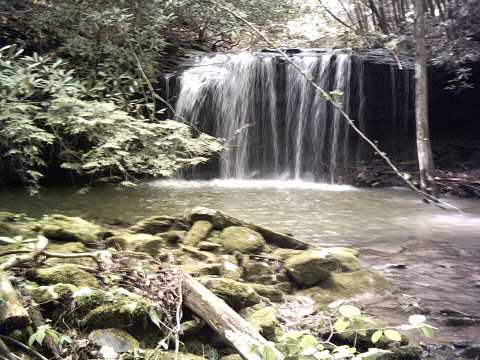
Chris Oliver reports wet-weather falls downsteam at
36.127564,-84.740558,
Tennessee landforms
home
arches
waterfalls
rocks
peaks
balds
sinks
lakes
regions
county
GSMNP landforms (TN/NC)
BSF landforms (TN/KY)
or nearby
lookout towers
 ©
Tom Dunigan
©
Tom Dunigan