Tennessee Landforms -- waterfalls| WGS84 |
| 35.935300 | -83.831400 |
| 35° 56.118'N | 83° 49.884'W |
| 35° 56' 7.1"N | 83° 49' 53"W |
| 17S 244572E 3980478N |
| convert to NAD27 |
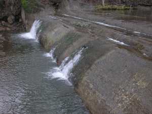
Burnett Creek Falls 8'
Waypoint: KNF003 35.935300,-83.831400
County: Knox landforms of Knox county
Locale: private
popup list of
nearby landforms (mileage, bearing)
MAPS
Select one of the following maps to display this waypoint (WGS84).
GPS
Remarks:
Reference: Kevin Baker
Tennessee landforms
home
arches
waterfalls
rocks
peaks
balds
sinks
lakes
regions
county
GSMNP landforms (TN/NC)
BSF landforms (TN/KY)
or nearby
lookout towers
 ©
Tom Dunigan
©
Tom Dunigan