Tennessee Landforms -- waterfalls| WGS84 |
| 36.252389 | -85.570583 |
| 36° 15.143'N | 85° 34.235'W |
| 36° 15' 8.6"N | 85° 34' 14.1"W |
| 16S 628422E 4012890N |
| convert to NAD27 |
Cynthia Falls 45'
Waypoint: JAF014 36.252389,-85.570583
County: Jackson landforms of Jackson county
popup list of
nearby landforms (mileage, bearing)
MAPS
Select one of the following maps to display this waypoint (WGS84).
GPS
Remarks:
Reference and photo: Scott Morell
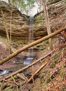 wet-weather falls
Tennessee landforms
home
arches
waterfalls
rocks
peaks
balds
sinks
lakes
regions
county
GSMNP landforms (TN/NC)
BSF landforms (TN/KY)
or nearby
lookout towers
 ©
Tom Dunigan
©
Tom Dunigan