Tennessee Landforms -- waterfalls| WGS84 |
| 36.482220 | -82.672100 |
| 36° 28.933'N | 82° 40.326'W |
| 36° 28' 56"N | 82° 40' 19.6"W |
| 17S 350214E 4038736N |
| convert to NAD27 |
Logger Falls (2) 30'
Waypoint: HWF010 36.482220,-82.672100
County: Hawkins landforms of Hawkins county
Locale: private
popup list of
nearby landforms (mileage, bearing)
MAPS
Select one of the following maps to display this waypoint (WGS84).
GPS
Remarks:
Reference and photos: Dave Aldridge
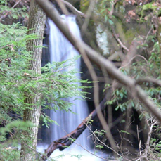
 15' upper falls is upstream at 36.48016,-82.67166
Tennessee landforms
home
arches
waterfalls
rocks
peaks
balds
sinks
lakes
regions
county
GSMNP landforms (TN/NC)
BSF landforms (TN/KY)
or nearby
lookout towers
Chuck Sutherland's www.tnlandforms.com the future (2024)
 ©
Tom Dunigan
©
Tom Dunigan