Tennessee Landforms -- waterfalls| WGS84 |
| 35.369900 | -85.180100 |
| 35° 22.194'N | 85° 10.806'W |
| 35° 22' 11.6"N | 85° 10' 48.4"W |
| 16S 665327E 3915585N |
| convert to NAD27 |
Little Possum Cascade 9'
Waypoint: HMF015 35.369900,-85.180100
County: Hamilton landforms of Hamilton county
Locale: Cumberland Trail
popup list of
nearby landforms (mileage, bearing)
MAPS
Select one of the following maps to display this waypoint (WGS84).
GPS
Remarks:
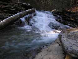 Imodium Falls is just down stream.
Tennessee landforms
home
arches
waterfalls
rocks
peaks
balds
sinks
lakes
regions
county
GSMNP landforms (TN/NC)
BSF landforms (TN/KY)
or nearby
lookout towers
 ©
Tom Dunigan
©
Tom Dunigan