Tennessee Landforms -- waterfalls| WGS84 |
| 35.359700 | -85.807400 |
| 35° 21.582'N | 85° 48.444'W |
| 35° 21' 34.9"N | 85° 48' 26.6"W |
| 16S 608351E 3913586N |
| convert to NAD27 |
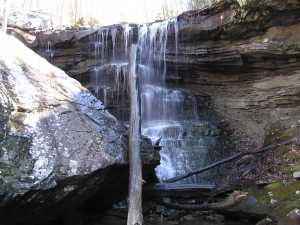
Nunley Hollow Falls 35'
Waypoint: GUF030 35.359700,-85.807400
County: Grundy landforms of Grundy county
Locale: private
popup list of
nearby landforms (mileage, bearing)
MAPS
Select one of the following maps to display this waypoint (WGS84).
GPS
Remarks:
wet-weather falls, picture of middle falls
Tennessee landforms
home
arches
waterfalls
rocks
peaks
balds
sinks
lakes
regions
county
GSMNP landforms (TN/NC)
BSF landforms (TN/KY)
or nearby
lookout towers
 ©
Tom Dunigan
©
Tom Dunigan