Tennessee Landforms -- waterfalls| WGS84 |
| 35.976500 | -82.849200 |
| 35° 58.59'N | 82° 50.952'W |
| 35° 58' 35.4"N | 82° 50' 57.1"W |
| 17S 333278E 3982923N |
| convert to NAD27 |
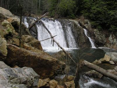
Kelley Falls 20'
Waypoint: GEF004 35.976500,-82.849200
County: Greene landforms of Greene county
Locale: Cherokee National Forest
popup list of
nearby landforms (mileage, bearing)
MAPS
Select one of the following maps to display this waypoint (WGS84).
GPS
Remarks:
Tennessee landforms
home
arches
waterfalls
rocks
peaks
balds
sinks
lakes
regions
county
GSMNP landforms (TN/NC)
BSF landforms (TN/KY)
or nearby
lookout towers
 ©
Tom Dunigan
©
Tom Dunigan