Tennessee Landforms -- arches and natural bridges| WGS84 |
| 35.113000 | -85.974200 |
| 35° 6.78'N | 85° 58.452'W |
| 35° 6' 46.8"N | 85° 58' 27.1"W |
| 16S 593479E 3886056N |
| convert to NAD27 |
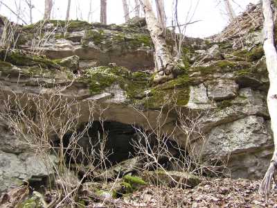
Reuben Double Arch 9x5
Waypoint: FRA006 35.113000,-85.974200
County: Franklin landforms of Franklin county
Locale: private
NABSQNO 16S-593479-3886056
popup list of
nearby landforms (mileage, bearing)
MAPS
Select one of the following maps to display this waypoint (WGS84).
GPS
Remarks:
Reference: Joette Carter
off-trail. Upper span is just starting to seperate from cliff wall making
this a limestone double arch.
Tennessee landforms
home
arches
waterfalls
rocks
peaks
balds
sinks
lakes
regions
county
GSMNP landforms (TN/NC)
BSF landforms (TN/KY)
or nearby
lookout towers
 ©
Tom Dunigan
©
Tom Dunigan