Tennessee Landforms -- rock formations| WGS84 |
| 36.541200 | -84.852100 |
| 36° 32.472'N | 84° 51.126'W |
| 36° 32' 28.3"N | 84° 51' 7.6"W |
| 16S 692267E 4046124N |
| convert to NAD27 |
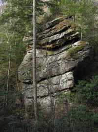
Pogue Chimney 50'
Waypoint: FER004 36.541200,-84.852100
County: Fentress landforms of Fentress county
Locale: PogueCreek
popup list of
nearby landforms (mileage, bearing)
MAPS
Select one of the following maps to display this waypoint (WGS84).
GPS
Remarks:
Tennessee landforms
home
arches
waterfalls
rocks
peaks
balds
sinks
lakes
regions
county
GSMNP landforms (TN/NC)
BSF landforms (TN/KY)
or nearby
lookout towers
 ©
Tom Dunigan
©
Tom Dunigan