Tennessee Landforms -- arches and natural bridges| WGS84 |
| 36.506300 | -84.767200 |
| 36° 30.378'N | 84° 46.032'W |
| 36° 30' 22.7"N | 84° 46' 1.9"W |
| 16S 699958E 4042425N |
| convert to NAD27 |
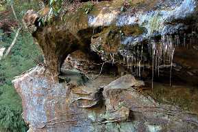
Crooked Br Window 6x3
Waypoint: FEA043 36.506300,-84.767200
County: Fentress landforms of Fentress county
Locale: Big South Fork
NABSQNO 16S-699958-4042425
popup list of
nearby landforms (mileage, bearing)
MAPS
Select one of the following maps to display this waypoint (WGS84).
GPS
Remarks:
Reference and photo: team Fife and Keith
Tennessee landforms
home
arches
waterfalls
rocks
peaks
balds
sinks
lakes
regions
county
GSMNP landforms (TN/NC)
BSF landforms (TN/KY)
or nearby
lookout towers
 ©
Tom Dunigan
©
Tom Dunigan