Tennessee Landforms -- arches and natural bridges| WGS84 |
| 36.536800 | -84.830800 |
| 36° 32.208'N | 84° 49.848'W |
| 36° 32' 12.5"N | 84° 49' 50.9"W |
| 16S 694185E 4045679N |
| convert to NAD27 |
Ascending Windows 4x2
Waypoint: FEA028 36.536800,-84.830800
County: Fentress landforms of Fentress county
Locale: PogueCreek
NABSQNO 16S-694185-4045679
popup list of
nearby landforms (mileage, bearing)
MAPS
Select one of the following maps to display this waypoint (WGS84).
GPS
Remarks:
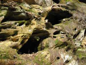
small set of rock windows on the west cliff wall. off-trail, Pogue Creek Tract, recent Nature Conservancy
acquisition.
Byron Jorjorian photos
Tennessee landforms
home
arches
waterfalls
rocks
peaks
balds
sinks
lakes
regions
county
GSMNP landforms (TN/NC)
BSF landforms (TN/KY)
or nearby
lookout towers
 ©
Tom Dunigan
©
Tom Dunigan