Tennessee Landforms -- arches and natural bridges| WGS84 |
| 36.527600 | -84.819800 |
| 36° 31.656'N | 84° 49.188'W |
| 36° 31' 39.4"N | 84° 49' 11.3"W |
| 16S 695193E 4044681N |
| convert to NAD27 |
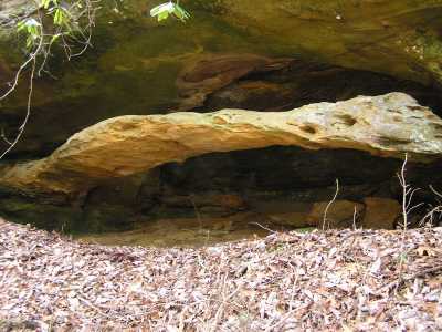
Pogue Arch 30x5
Waypoint: FEA024 36.527600,-84.819800
County: Fentress landforms of Fentress county
Locale: PogueCreek
NABSQNO 16S-695193-4044681
popup list of
nearby landforms (mileage, bearing)
MAPS
Select one of the following maps to display this waypoint (WGS84).
GPS
Remarks:
off-trail, Pogue Creek Tract, recent Nature Conservancy
acquisition and statue
natural area.
Byron Jorjorian photos
Tennessee landforms
home
arches
waterfalls
rocks
peaks
balds
sinks
lakes
regions
county
GSMNP landforms (TN/NC)
BSF landforms (TN/KY)
or nearby
lookout towers
 ©
Tom Dunigan
©
Tom Dunigan