Tennessee Landforms -- waterfalls| WGS84 |
| 35.834700 | -85.649200 |
| 35° 50.082'N | 85° 38.952'W |
| 35° 50' 4.9"N | 85° 38' 57.1"W |
| 16S 622002E 3966457N |
| convert to NAD27 |
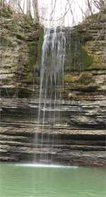
Wright Falls 35'
Waypoint: DKF007 35.834700,-85.649200
County: DeKalb landforms of DeKalb county
Locale: CenterHill
popup list of
nearby landforms (mileage, bearing)
MAPS
Select one of the following maps to display this waypoint (WGS84).
GPS
Remarks:
wet-weather falls
Tennessee landforms
home
arches
waterfalls
rocks
peaks
balds
sinks
lakes
regions
county
GSMNP landforms (TN/NC)
BSF landforms (TN/KY)
or nearby
lookout towers
 ©
Tom Dunigan
©
Tom Dunigan