Tennessee Landforms -- arches and natural bridges| WGS84 |
| 36.023550 | -85.874940 |
| 36° 1.413'N | 85° 52.496'W |
| 36° 1' 24.8"N | 85° 52' 29.8"W |
| 16S 601371E 3987146N |
| convert to NAD27 |
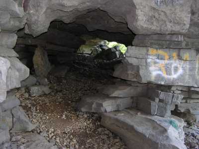
Indian Creek Arch 4x4
Waypoint: DKA002 36.023550,-85.874940
County: DeKalb landforms of DeKalb county
Locale: CenterHill
NABSQNO 16S-601371-3987146
popup list of
nearby landforms (mileage, bearing)
MAPS
Select one of the following maps to display this waypoint (WGS84).
GPS
Remarks:
Reference: Vic Fife
Tennessee landforms
home
arches
waterfalls
rocks
peaks
balds
sinks
lakes
regions
county
GSMNP landforms (TN/NC)
BSF landforms (TN/KY)
or nearby
lookout towers
 ©
Tom Dunigan
©
Tom Dunigan