Tennessee Landforms -- waterfalls| WGS84 |
| 35.766092 | -84.964874 |
| 35° 45.966'N | 84° 57.892'W |
| 35° 45' 58"N | 84° 57' 53.5"W |
| 16S 683974E 3959915N |
| convert to NAD27 |
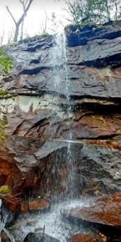
Pond Cove Falls 40'
Waypoint: CUF012 35.766092,-84.964874
County: Cumberland landforms of Cumberland county
Locale: CT
popup list of
nearby landforms (mileage, bearing)
MAPS
Select one of the following maps to display this waypoint (WGS84).
GPS
Remarks:
Reference and photo: Shauna Wilson
Tennessee landforms
home
arches
waterfalls
rocks
peaks
balds
sinks
lakes
regions
county
GSMNP landforms (TN/NC)
BSF landforms (TN/KY)
or nearby
lookout towers
 ©
Tom Dunigan
©
Tom Dunigan