Tennessee Landforms -- waterfalls| WGS84 |
| 35.836040 | -82.968710 |
| 35° 50.162'N | 82° 58.123'W |
| 35° 50' 9.7"N | 82° 58' 7.4"W |
| 17S 322187E 3967552N |
| convert to NAD27 |
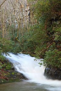
Cliff Dwellers Cascade 15'
Waypoint: COF012 35.836040,-82.968710
County: Cocke landforms of Cocke county
Locale: Cherokee National Forest
popup list of
nearby landforms (mileage, bearing)
MAPS
Select one of the following maps to display this waypoint (WGS84).
GPS
Remarks:
Reference and photo: Thomas Mabry, Andy Kunkle
Tennessee landforms
home
arches
waterfalls
rocks
peaks
balds
sinks
lakes
regions
county
GSMNP landforms (TN/NC)
BSF landforms (TN/KY)
or nearby
lookout towers
 ©
Tom Dunigan
©
Tom Dunigan