Tennessee Landforms -- waterfalls| WGS84 |
| 35.435600 | -86.148900 |
| 35° 26.136'N | 86° 8.934'W |
| 35° 26' 8.2"N | 86° 8' 56"W |
| 16S 577251E 3921684N |
| convert to NAD27 |
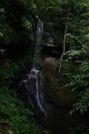
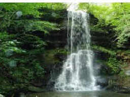
Vann Falls 60'
Waypoint: CFF016 35.435600,-86.148900
County: Coffee landforms of Coffee county
Locale: private
popup list of
nearby landforms (mileage, bearing)
MAPS
Select one of the following maps to display this waypoint (WGS84).
GPS
Remarks:
Reference & photo: sadhish siva
 real estate photo
Tennessee landforms
home
arches
waterfalls
rocks
peaks
balds
sinks
lakes
regions
county
GSMNP landforms (TN/NC)
BSF landforms (TN/KY)
or nearby
lookout towers
 ©
Tom Dunigan
©
Tom Dunigan