Tennessee Landforms -- waterfalls| WGS84 |
| 35.424260 | -86.220680 |
| 35° 25.456'N | 86° 13.241'W |
| 35° 25' 27.4"N | 86° 13' 14.5"W |
| 16S 570746E 3920372N |
| convert to NAD27 |
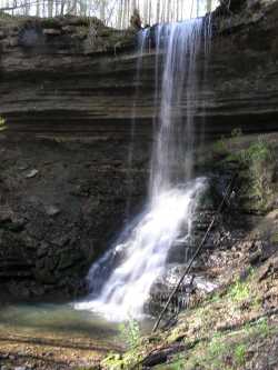
Little Copperas Falls 35'
Waypoint: CFF013 35.424260,-86.220680
County: Coffee landforms of Coffee county
popup list of
nearby landforms (mileage, bearing)
MAPS
Select one of the following maps to display this waypoint (WGS84).
GPS
Remarks:
Tennessee landforms
home
arches
waterfalls
rocks
peaks
balds
sinks
lakes
regions
county
GSMNP landforms (TN/NC)
BSF landforms (TN/KY)
or nearby
lookout towers
 ©
Tom Dunigan
©
Tom Dunigan