Tennessee Landforms -- waterfalls| WGS84 |
| 36.443440 | -84.057890 |
| 36° 26.606'N | 84° 3.473'W |
| 36° 26' 36.4"N | 84° 3' 28.4"W |
| 16S 763707E 4037158N |
| convert to NAD27 |
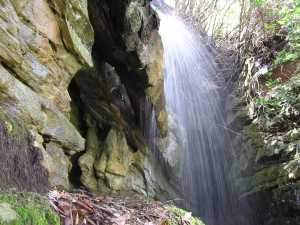
Circle Falls 40'
Waypoint: CAF023 36.443440,-84.057890
County: Campbell landforms of Campbell county
Locale: private
popup list of
nearby landforms (mileage, bearing)
MAPS
Select one of the following maps to display this waypoint (WGS84).
GPS
Remarks:
A wet-weather falls tumbles 40' through
three natural bridges and then
drops another 50'.
 top tier
Tennessee landforms
home
arches
waterfalls
rocks
peaks
balds
sinks
lakes
regions
county
GSMNP landforms (TN/NC)
BSF landforms (TN/KY)
or nearby
lookout towers
 ©
Tom Dunigan
©
Tom Dunigan