Tennessee Landforms -- waterfalls| WGS84 |
| 36.447200 | -84.133600 |
| 36° 26.832'N | 84° 8.016'W |
| 36° 26' 49.9"N | 84° 8' 1"W |
| 16S 756907E 4037371N |
| convert to NAD27 |
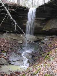
Small Hollow Falls 18'
Waypoint: CAF017 36.447200,-84.133600
County: Campbell landforms of Campbell county
popup list of
nearby landforms (mileage, bearing)
MAPS
Select one of the following maps to display this waypoint (WGS84).
GPS
Remarks:
wet-weather falls, off-trail
Tennessee landforms
home
arches
waterfalls
rocks
peaks
balds
sinks
lakes
regions
county
GSMNP landforms (TN/NC)
BSF landforms (TN/KY)
or nearby
lookout towers
 ©
Tom Dunigan
©
Tom Dunigan