Tennessee Landforms -- waterfalls| WGS84 |
| 36.320100 | -84.277200 |
| 36° 19.206'N | 84° 16.632'W |
| 36° 19' 12.4"N | 84° 16' 37.9"W |
| 16S 744432E 4022895N |
| convert to NAD27 |
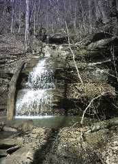
Wheeler Creek Falls 30'
Waypoint: CAF016 36.320100,-84.277200
County: Campbell landforms of Campbell county
Locale: RoyalBlue
popup list of
nearby landforms (mileage, bearing)
MAPS
Select one of the following maps to display this waypoint (WGS84).
GPS
Remarks:
Reference: Kevin Baker
Tennessee landforms
home
arches
waterfalls
rocks
peaks
balds
sinks
lakes
regions
county
GSMNP landforms (TN/NC)
BSF landforms (TN/KY)
or nearby
lookout towers
 ©
Tom Dunigan
©
Tom Dunigan