Tennessee Landforms -- waterfalls| WGS84 |
| 36.306400 | -84.245200 |
| 36° 18.384'N | 84° 14.712'W |
| 36° 18' 23"N | 84° 14' 42.7"W |
| 16S 747348E 4021456N |
| convert to NAD27 |
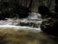
Duncan Branch Falls(m) 8'
Waypoint: CAF010 36.306400,-84.245200
County: Campbell landforms of Campbell county
Locale: RoyalBlue
popup list of
nearby landforms (mileage, bearing)
MAPS
Select one of the following maps to display this waypoint (WGS84).
GPS
Remarks:
Reference: Kevin Baker
middle falls just downstream from ATV crossing
Tennessee landforms
home
arches
waterfalls
rocks
peaks
balds
sinks
lakes
regions
county
GSMNP landforms (TN/NC)
BSF landforms (TN/KY)
or nearby
lookout towers
 ©
Tom Dunigan
©
Tom Dunigan