Tennessee Landforms -- waterfalls| WGS84 |
| 36.434600 | -84.165400 |
| 36° 26.076'N | 84° 9.924'W |
| 36° 26' 4.6"N | 84° 9' 55.4"W |
| 16S 754097E 4035888N |
| convert to NAD27 |
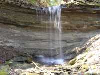
Waterfall Branch Falls 22'
Waypoint: CAF007 36.434600,-84.165400
County: Campbell landforms of Campbell county
Locale: RoyalBlue
popup list of
nearby landforms (mileage, bearing)
MAPS
Select one of the following maps to display this waypoint (WGS84).
GPS
Remarks:
Tennessee landforms
home
arches
waterfalls
rocks
peaks
balds
sinks
lakes
regions
county
GSMNP landforms (TN/NC)
BSF landforms (TN/KY)
or nearby
lookout towers
 ©
Tom Dunigan
©
Tom Dunigan