Tennessee Landforms -- arches and natural bridges| WGS84 |
| 36.326720 | -84.224290 |
| 36° 19.603'N | 84° 13.457'W |
| 36° 19' 36.2"N | 84° 13' 27.4"W |
| 16S 749161E 4023764N |
| convert to NAD27 |
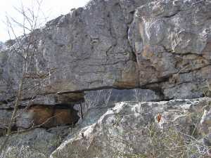
Devil's Eye 5x2
Waypoint: CAA012 36.326720,-84.224290
County: Campbell landforms of Campbell county
NABSQNO 16S-749161-4023764
popup list of
nearby landforms (mileage, bearing)
MAPS
Select one of the following maps to display this waypoint (WGS84).
GPS
Remarks:
A rock window on the southern most fin of the
Devil's Racetrack
Tennessee landforms
home
arches
waterfalls
rocks
peaks
balds
sinks
lakes
regions
county
GSMNP landforms (TN/NC)
BSF landforms (TN/KY)
or nearby
lookout towers
 ©
Tom Dunigan
©
Tom Dunigan