Tennessee Landforms -- waterfalls| WGS84 |
| 35.568130 | -83.805710 |
| 35° 34.088'N | 83° 48.343'W |
| 35° 34' 5.3"N | 83° 48' 20.6"W |
| 17S 245723E 3939673N |
| convert to NAD27 |
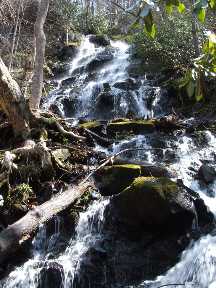
Sugar Cove Branch Falls 40'
Waypoint: BTF028 35.568130,-83.805710
County: Blount landforms of Blount county
Locale: Great Smoky Mountains National Park
popup list of
nearby landforms (mileage, bearing)
MAPS
Select one of the following maps to display this waypoint (WGS84).
GPS
Remarks:
Reference and photo: Byron Hartzler
 off-trail
Tennessee landforms
home
arches
waterfalls
rocks
peaks
balds
sinks
lakes
regions
county
GSMNP landforms (TN/NC)
BSF landforms (TN/KY)
or nearby
lookout towers
 ©
Tom Dunigan
©
Tom Dunigan