Tennessee Landforms -- waterfalls| WGS84 |
| 35.485900 | -83.937600 |
| 35° 29.154'N | 83° 56.256'W |
| 35° 29' 9.2"N | 83° 56' 15.4"W |
| 17S 233495E 3930898N |
| convert to NAD27 |
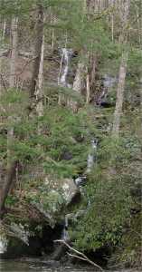
Calderwood Cascade 18'
Waypoint: BTF021 35.485900,-83.937600
County: Blount landforms of Blount county
Locale: Calderwood
popup list of
nearby landforms (mileage, bearing)
MAPS
Select one of the following maps to display this waypoint (WGS84).
GPS
Remarks:
wet-weather cascade
Tennessee landforms
home
arches
waterfalls
rocks
peaks
balds
sinks
lakes
regions
county
GSMNP landforms (TN/NC)
BSF landforms (TN/KY)
or nearby
lookout towers
 ©
Tom Dunigan
©
Tom Dunigan