Tennessee Landforms -- waterfalls| WGS84 |
| 35.476900 | -83.950100 |
| 35° 28.614'N | 83° 57.006'W |
| 35° 28' 36.8"N | 83° 57' 0.4"W |
| 17S 232331E 3929933N |
| convert to NAD27 |
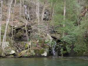
Tunnel Cascade 40'
Waypoint: BTF020 35.476900,-83.950100
County: Blount landforms of Blount county
Locale: Calderwood
popup list of
nearby landforms (mileage, bearing)
MAPS
Select one of the following maps to display this waypoint (WGS84).
GPS
Remarks:
wet-weather cascade near the submerged tunnel
Tennessee landforms
home
arches
waterfalls
rocks
peaks
balds
sinks
lakes
regions
county
GSMNP landforms (TN/NC)
BSF landforms (TN/KY)
or nearby
lookout towers
 ©
Tom Dunigan
©
Tom Dunigan