Tennessee Landforms -- waterfalls| WGS84 |
| 35.635470 | -83.746040 |
| 35° 38.128'N | 83° 44.762'W |
| 35° 38' 7.7"N | 83° 44' 45.7"W |
| 17S 251341E 3946991N |
| convert to NAD27 |
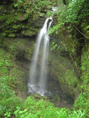
Whiteoak Sink Falls 40'
Waypoint: BTF008 35.635470,-83.746040
County: Blount landforms of Blount county
Locale: Great Smoky Mountains National Park
popup list of
nearby landforms (mileage, bearing)
MAPS
Select one of the following maps to display this waypoint (WGS84).
GPS
Remarks:
A small stream falls 40 feet directly into the mouth of a cave
(off-trail/manway).
geology
info and pics
Tennessee landforms
home
arches
waterfalls
rocks
peaks
balds
sinks
lakes
regions
county
GSMNP landforms (TN/NC)
BSF landforms (TN/KY)
or nearby
lookout towers
 ©
Tom Dunigan
©
Tom Dunigan