Tennessee Landforms -- arches and natural bridges| WGS84 |
| 35.562400 | -83.800600 |
| 35° 33.744'N | 83° 48.036'W |
| 35° 33' 44.6"N | 83° 48' 2.2"W |
| 17S 246169E 3939024N |
| convert to NAD27 |
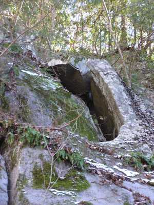
Mill Creek Arch 2x8
Waypoint: BTA002 35.562400,-83.800600
County: Blount landforms of Blount county
Locale: Great Smoky Mountains National Park
NABSQNO 17S-246169-3939024
popup list of
nearby landforms (mileage, bearing)
MAPS
Select one of the following maps to display this waypoint (WGS84).
GPS
Remarks:
A gravity arch at the top of the 200'+
cascade. If you've visited the
cascade and giant chestnut oak,
you might see if you can find this arch. off-trail
Tennessee landforms
home
arches
waterfalls
rocks
peaks
balds
sinks
lakes
regions
county
GSMNP landforms (TN/NC)
BSF landforms (TN/KY)
or nearby
lookout towers
 ©
Tom Dunigan
©
Tom Dunigan