Tennessee Landforms -- waterfalls| WGS84 |
| 36.084520 | -84.335900 |
| 36° 5.071'N | 84° 20.154'W |
| 36° 5' 4.3"N | 84° 20' 9.2"W |
| 16S 739879E 3996609N |
| convert to NAD27 |
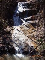
Cow Creek 25'
Waypoint: ANF004 36.084520,-84.335900
County: Anderson landforms of Anderson county
Locale: windrock
popup list of
nearby landforms (mileage, bearing)
MAPS
Select one of the following maps to display this waypoint (WGS84).
GPS
Remarks:
Reference and photo: Sharon Blackstock
Tennessee landforms
home
arches
waterfalls
rocks
peaks
balds
sinks
lakes
regions
county
GSMNP landforms (TN/NC)
BSF landforms (TN/KY)
or nearby
lookout towers
 ©
Tom Dunigan
©
Tom Dunigan