
arches waterfalls rocks peaks balds sinkholes lakes regions county
| Tennessee Landforms |
Revised
Sat, 23 Mar 2024 05:56:14 -0600 (908
falls, 369
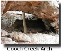
arches, 258
lakes, 49 rocks, 43 sinkholes, 20 balds, 13 peaks).
Corrections and additions welcomed.

This site has GPS waypoints (latitude/longitude WGS84) and maps to interesting landforms in Tennessee. Some of these landforms are on private property, get permission first. Other formations are diffcult to access because they are off-trail. Many of the locations for waterfalls and lakes were harvested from the USGS database. WARNING: Some of the waypoints are extrapolated from descriptions or trail maps (class B1 data). Many of the waypoints are from site visits with GPS. Over time, more of the sites will be visited and waypoints verified. Sites whose location are particularly "uncertain" are noted with "?". Many of the sites do not have "official" names. Get out and enjoy the natural wonders of Tennessee!
| arches | This section provides the location of over 369 arches, natural bridges, and rock windows in Tennessee. |
| waterfalls | This section provides the location of over 908 waterfalls in Tennessee. |
| rocks | This section provides the location of rock chimneys, rock gardens, and other curious rock formations in Tennessee |
| peaks | This section provides the location of the 13 Tennessee mountain peaks over 6000' and high points for each county. |
| balds | This section provides the location of the grassy balds along the mountain tops of East Tennessee. |
| sinkholes | This section provides the location of sinkholes that have depths over 100' and sinkholes of distinction for each county. |
| lakes | This section provides the location of over 258 lakes and reservoirs in Tennessee. |
| regions | This section provides the location of various geological regions, craters, and natural areas of Tennessee. |
| county | This section lists the landforms by county. |
Maps of the landforms include Maptech, CalTopo, sartopo, google maps, mytopo, TerraServer satellite/aerial images, and Mapquest. For some formations there are also pictures and additional information. The USGS topo maps use CONUS 1927 datum, which can be more than 200m off (north-south) from WGS84 for UTM, but is typically only 7m off for latitude/longitude in Tennessee. There is also a clickable map that displays the locations of waterfalls, natural bridges, etc. all on the same map, or a Google locator map select address or click on map.
| Waypoints |
Download waypoints (WGS84)
 Download these waypoint files (.gpx) and
use EasyGPS (free) to upload the waypoints
from your PC to your GPS.
Maptech .mxf
waypoint files are also provided, CSV format.
You can use gpsvisualizer.com or
CalTopo.com to upload and view the gpx files
on google map.
These files are continually being updated, so be sure you have
downloaded the latest version.
Last revised
Sat, 23 Mar 2024 05:56:14 -0600
Download these waypoint files (.gpx) and
use EasyGPS (free) to upload the waypoints
from your PC to your GPS.
Maptech .mxf
waypoint files are also provided, CSV format.
You can use gpsvisualizer.com or
CalTopo.com to upload and view the gpx files
on google map.
These files are continually being updated, so be sure you have
downloaded the latest version.
Last revised
Sat, 23 Mar 2024 05:56:14 -0600
|
 |
As if you didn't have enough maps to choose from already, this clickable state map will show arches, waterfalls, etc. all on a single scalable map. Also, USAPhotoMaps (shareware) will display multiple waypoints on the same topo or aerial image. See the commercial GPS/mapping products below, too.
| Related information |

Links
Tennessee


")
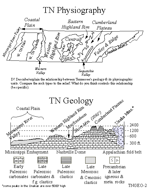
Geology

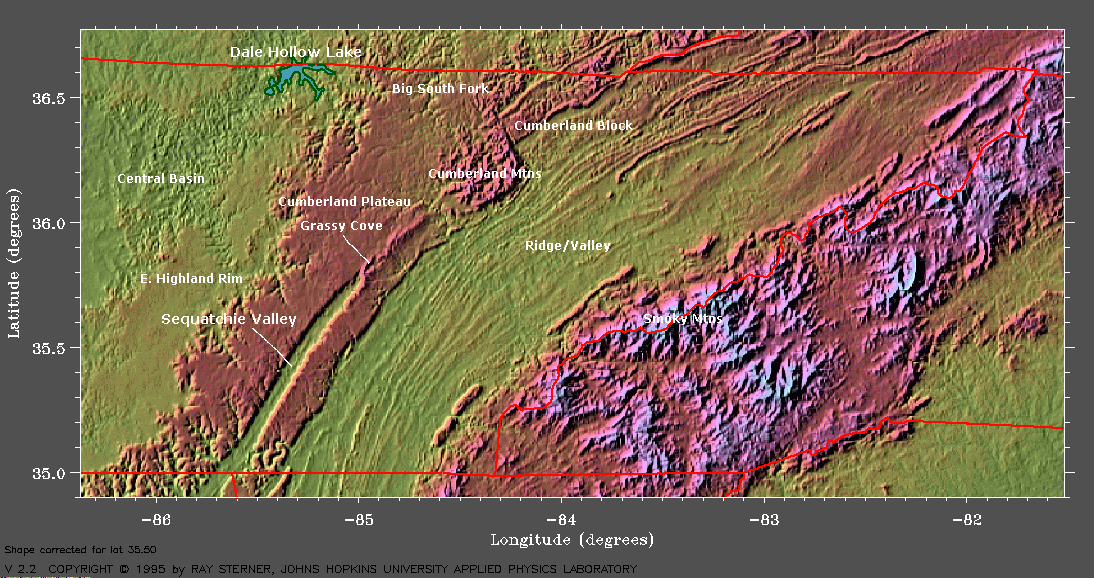
TN physiography illustration
geologic map of Tennessee
or
here
or here
TN
counties and landform regions
geology of
GSMNP Mt Leconte/ Abrams Falls
geology of Cades Cove
and another
Abrams Falls geology
Mt Leconte geology
geology of Ocoee River
and the whitewater center geology
karst regions/aquifers of TN
and limestone
geology
and
karst map and sinkholes
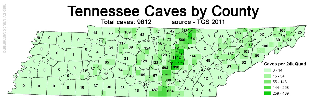
caves-per-county map 2013
TN
geology
and
geologic history
Tennessee
Division of Geology
East Tennessee Geological Society
and TN
GIS data
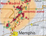
recent TN earthquakes
TN TN earthquake info
and
seismic hazard map
and
2014 TN seismic hazard map
East TN coal fields
or
here
and OSM reports
Kentucky geology
Kentucky landforms waterfalls, arches
and map
Georgia waterfalls
Maps
tn geospatial GIS data
or TN GIS data
and UT's TN map info
maps of national parks in Tennessee
clickable (zoom/pan) GSMNP trail map
and interactive 1931 park map
clickable USGS
quadrangle map of GSMNP, zoom/pan
our clickable TN map/location selector
or Google locator map select by address or click
on map
Google
map with distance and elevation tools
or google map with
profiles and contours
and more elevation data
or maplorer.com
Our google map with tracking and
elevation profiles
another google map nexrad
mytopo (a few glitches from new FS maps)
GSMNP
park maps (pdf's) '03

smoky mountains topo maps
TN USGS 7.5 topo quad maps by county
TN USGS topo
quad index map
TN TNMap TN GIS data
TN USGS map and GIS data topo tiffs
USGS topo quads (tiffs)
and
map symbols legend
new USGS topos (pdf)
and older topos (geo pdfs)
Gmap4 hi res topos
or CalTopo.com historic topos and hires topos
with track-draw/profiles/print and gpx import ★ ★
elevation data 10m DEM
and TN DEMs
Topoquest USGS map finder
National Geographic TrailSmart
topo CD , trail maps on topo, GPS-ready for BSF and GSMNP.
TN county maps
pdf
or Google county map
History of County Formations in Tennessee 1776-1985 or
historic 1888 county maps
1786
state of Franklin
TDOT state google map
road conditions
TWRA maps WMA's,
some lakes
East TN landform map
and WorldAtlas Tennessee landforms
historical
maps of the Great Smoky Mountains
TN
geologic maps
and
karst map
TN
historical maps
or here
or here
or here
or
here
various generations of TN topo maps
or here
or here
pre-1945 USGS
topographic maps
and USGS
and
historic/current pdf's
Historical Quadrangle Scanning Project (HQSP)
geographic
center of Tennessee
and waymark
remotest point in Tennessee
3-D fly thru maps
Cades Coves, TN river gorge, Albright Grove
ravenmaps.com
state map or gisgeography
state maps
geology.com
Tennessee maps county, elevation
My Google maps
arches
falls
GSMNP
BSF
towers
greenways
blueway
county high points
AT shelters
(most have iPhone google map option)
 |
Google Earth KML files based on our waypoints:
TN waterfalls falls.kmz and arches arches.kmz Big South Fork landforms bsf.kmz Smoky Mountains landforms gsmnp.kmz or campsites camp.kmz or trails.kmz trails (2/22/08) TN lookout towers towers.kmz Appalachian Trail shelters atshelters.kmz and parking atparking.kmz Oak Ridge greenways gw.kmz |
Books
Plumb's
Waterfalls of Tennessee ratings, directions (2nd edition)
McDade's
Natural Arches of the Big South Fork (10+ in TN)
Corgan/Parks
Natural Bridges of Tennessee 1979 bulletin (36+)
Barr's
Caves of Tennessee (700+) 1961 bulletin
or Mathews
Descriptions of Tennessee Caves 1971 bulletin
Tennessee Topography, bulletin #86, David Starnes, 2009.
A study of the topography of Tennessee, including area data; high and low elevations; elevations of cities, towns, and rural communities; major topographic features; and a general description of the topography and water features of each of the state's 95 counties. Includes topographic indexes for each county and measurements of land and water area and physiographic provinces; a summary of Tennessee's physiographic provinces, general geology, and drainage basins, plus a brief discussion of topographic maps; 4 appendixes, a glossary, and a list of suggested readings and additional resources
 GPS info
Bring a compass. It's awkward when you have to eat your friends.
GPS info
Bring a compass. It's awkward when you have to eat your friends.
Tennessee landforms home arches waterfalls rocks peaks balds sinkholes lakes regions county

visitors since 12/20/02
©
Tom Dunigan 2002
Last modified:
Sat, 23 Mar 2024 05:56:14 -0600 1232309
To pour forth benefits for the common good is divine. -- Ben Franklin