Great Smoky Mountains National Park Landforms| WGS84 |
| 35.600000 | -83.516100 |
| 35° 36'N | 83° 30.966'W |
| 35° 36' 0"N | 83° 30' 58"W |
| 17S 272066E 3942499N |
| convert to NAD27 |
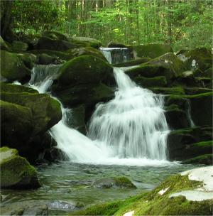
Little River Upper Falls 8'
Waypoint: SVF048 35.600000,-83.516100
Locale: Sevier
popup list of
nearby landforms/campsites (mileage, bearing)
MAPS
Select one of the following maps to display this waypoint (WGS84).
GPS
Remarks:
GSMNP landforms and campsites
and
trails (TN/NC)
 AT shelters
BSF landforms (TN/KY)
AT shelters
BSF landforms (TN/KY)
Tennessee landforms
home
arches
waterfalls
rocks
peaks
balds
sinkholes
lakes
regions
 ©
Tom Dunigan
©
Tom Dunigan