Great Smoky Mountains National Park Campsites| WGS84 |
| 35.610154 | -83.368552 |
| 35° 36.609'N | 83° 22.113'W |
| 35° 36' 36.5"N | 83° 22' 6.8"W |
| 17S 285463E 3943293N |
| convert to NAD27 |
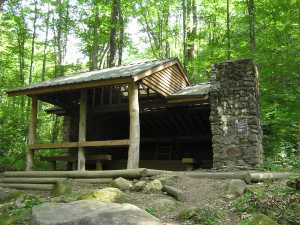
SHELTER KEPHART 
Waypoint: SHKPHT 35.610154,-83.368552
Locale: Oconaluftee KephartProng
Elevation: 3540'
reservation and fee required
GSMNP camping info permits, fees, reservations etc.
popup list of
nearby landforms/campsites (mileage, bearing)
MAPS
Select one of the following maps to display this waypoint (WGS84).
GPS
Remarks:
Reservation required: max 14 people, 14 horses
GSMNP landforms and campsites
and
trails (TN/NC)
 AT shelters
BSF landforms (TN/KY)
AT shelters
BSF landforms (TN/KY)
Tennessee landforms
home
arches
waterfalls
rocks
peaks
balds
sinkholes
lakes
regions
 ©
Tom Dunigan
©
Tom Dunigan