Great Smoky Mountains National Park Landforms| WGS84 |
| 35.601300 | -83.327700 |
| 35° 36.078'N | 83° 19.662'W |
| 35° 36' 4.7"N | 83° 19' 39.7"W |
| 17S 289140E 3942222N |
| convert to NAD27 |
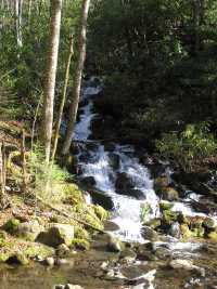
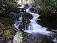
Taywa Creek Cascade 30'
Waypoint: NCF026 35.601300,-83.327700
Locale: NC
popup list of
nearby landforms/campsites (mileage, bearing)
MAPS
Select one of the following maps to display this waypoint (WGS84).
GPS
Remarks:
A long series of cascades emptying into Bradley Fork.
GSMNP landforms and campsites
and
trails (TN/NC)
 AT shelters
BSF landforms (TN/KY)
AT shelters
BSF landforms (TN/KY)
Tennessee landforms
home
arches
waterfalls
rocks
peaks
balds
sinkholes
lakes
regions
 ©
Tom Dunigan
©
Tom Dunigan