Great Smoky Mountains National Park Landforms| WGS84 |
| 35.471100 | -83.869800 |
| 35° 28.266'N | 83° 52.188'W |
| 35° 28' 16"N | 83° 52' 11.3"W |
| 17S 239600E 3929074N |
| convert to NAD27 |
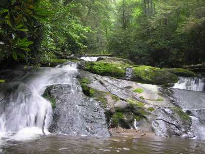
Twentymile Creek Cascade 18'
Waypoint: NCF017 35.471100,-83.869800
Locale: NC
popup list of
nearby landforms/campsites (mileage, bearing)
MAPS
Select one of the following maps to display this waypoint (WGS84).
GPS
Remarks:
GSMNP landforms and campsites
and
trails (TN/NC)
 AT shelters
BSF landforms (TN/KY)
AT shelters
BSF landforms (TN/KY)
Tennessee landforms
home
arches
waterfalls
rocks
peaks
balds
sinkholes
lakes
regions
 ©
Tom Dunigan
©
Tom Dunigan