Great Smoky Mountains National Park Landforms| WGS84 |
| 35.466660 | -83.429950 |
| 35° 28'N | 83° 25.797'W |
| 35° 28' 0"N | 83° 25' 47.8"W |
| 17S 279508E 3927510N |
| convert to NAD27 |
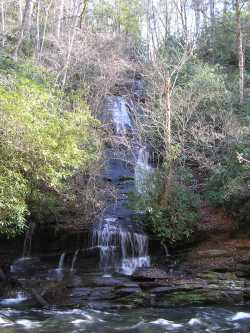
Tom Branch Falls 80'
Waypoint: NCF013 35.466660,-83.429950
Locale: NC
popup list of
nearby landforms/campsites (mileage, bearing)
MAPS
Select one of the following maps to display this waypoint (WGS84).
GPS
Remarks:
best viewed in winter
GSMNP landforms and campsites
and
trails (TN/NC)
 AT shelters
BSF landforms (TN/KY)
AT shelters
BSF landforms (TN/KY)
Tennessee landforms
home
arches
waterfalls
rocks
peaks
balds
sinkholes
lakes
regions
 ©
Tom Dunigan
©
Tom Dunigan