Great Smoky Mountains National Park Landforms| WGS84 |
| 35.605420 | -83.768836 |
| 35° 36.325'N | 83° 46.13'W |
| 35° 36' 19.5"N | 83° 46' 7.8"W |
| 17S 249182E 3943715N |
| convert to NAD27 |
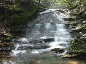
Sliding Rock Cascade 8'
Waypoint: BTF030 35.605420,-83.768836
Locale: Blount
popup list of
nearby landforms/campsites (mileage, bearing)
MAPS
Select one of the following maps to display this waypoint (WGS84).
GPS
Remarks:
Reference and photo: Byron Hartzler
GSMNP landforms and campsites
and
trails (TN/NC)
 AT shelters
BSF landforms (TN/KY)
AT shelters
BSF landforms (TN/KY)
Tennessee landforms
home
arches
waterfalls
rocks
peaks
balds
sinkholes
lakes
regions
 ©
Tom Dunigan
©
Tom Dunigan