
The following table lists coordinates for trailheads and trail junctions
on the Oak Ridge greenways.
You can select the greenway map by clicking in the Trailhead column,
or the Google map by clicking on the waypoint.
 GPS data files are provided in GPX (use EasyGPS ) and
Maptech MXF format for downloading to
your GPS.
You can enter lat,lon into the Search box of your iPhone map apps.
GPS data files are provided in GPX (use EasyGPS ) and
Maptech MXF format for downloading to
your GPS.
You can enter lat,lon into the Search box of your iPhone map apps.
.... under construction ... 6/27/10
GPS waypoint files:
gw.gpx or gw.mxf
send waypoints to Garmin GPS
• Trailhead parking indicated on a
Google
map/image with trails, iPhone map
•
Google Earth KML file gw.kmz
• Greenways trails (GPS) gwtrails.gpx
• leafletjs Greenway map
• Greenways maps
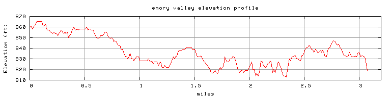
• Emory Valley
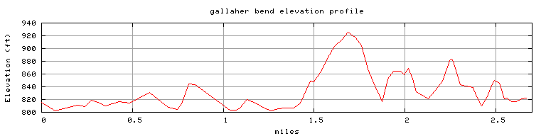
GPS track elevation profiles
•
Elevation profiles:
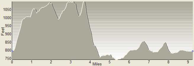
North Ridge
or
Melton Lake
or
North Boundary
or
Gallaher Bend
or
Emory Valley
 GPS info