Length: 4.3 miles, rated easy, maps:
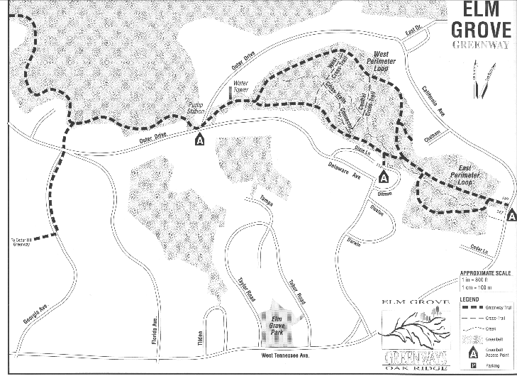
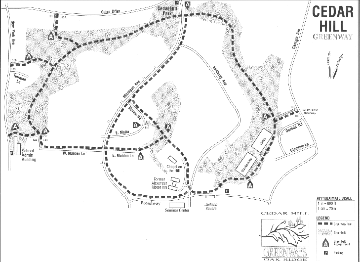
Elm grove and Cedar Hill.
Also see Cedar Hill trail log.
This tour utilizes two major Oak Ridge greenbelts within the eastern residential portion of the city. The tour as described here comprises several separate greenway paths (linked by city streets), as envisioned by Greenways Oak Ridge (an informal citizens group), and opened in 1993-1994. It thus combines 3.4 miles of "woods walking" with 0.9 mile of linking pavement. Greenways paths are marked with pink ribbons. A car shuttle is recommended to return hikers from the tour's end back to the start. Free maps for the two Greenways Oak Ridge portions are available at Oak Ridge Public Library.
This tour begins at a trailhead between residences at 147 and 149 California Avenue, and follows the valley up to a city water tower at the top of the ridge, for a distance of 1.2 mile. Several side loops are available to the hiker for exploration (see map), but the mileage quoted is based on consistently selecting the right-hand option at all forks.
Follow the asphalt road from the water tower down to Outer Drive, thence to the city pumping station, a distance of 0.15 mile. This point is the trailhead for two other trails which are marked by blue and red painted blazes. This tour follows Greenways pink ribbons along a woodland path for 0.4 mile to a junction with the Georgia Access Trail (which leads (right) to the North Ridge Trail). Turn left, and follow the Georgia Access Trail for 0.12 mile to its trailhead on Outer Drive.
Cross Outer Drive and proceed down Georgia Avenue for 0.25 mile. Turn right at a trail kiosk located between residences at 100 Gordon Lane and 127 Georgia Avenue, and follow a short access trail between two fences to its junction with a Greenways trail which leads up from Jackson Square. Here turn right, cross a soccer field, and enter a wooded area by a trail marked with pink-painted blazes for a short distance. The trail ascends gradually for 0.6 mile to Kentucky Avenue.
Cross Kentucky Avenue, and proceed across Cedar Hill Park (picnic tables) to a large trail sign which marks Cedar Hill Greenway through Oak Ridge wooded greenbelt. The Greenway descends slowly for 0.7 mile to West Maiden Lane. The tour follows West Maiden Lane and East Maiden Lane (0.3 mile), then enters open woods. After 0.1 mile through the woods, it passes "The Chapel on the Hill", a landmark dating back to World War II, and arrives at Jackson Square parking lot for the end of the 4.3-mile tour.
This first portion of Melton Lake Greenway was opened in December, 1997, and consists of 1.26 miles of a nearly level asphalted surface, ideal for bicycling and skating, in addition to walking. Melton Lake Greenway has been squeezed in between Melton Lake Drive and the shore of Melton Hill Lake (the former Clinch River). Its two termini lie adjacent to intersections of Melton Lake Drive with Amanda Drive, and the entrance to Rivers Run, respectively.
Starting at the northern end of Melton Lake Greenway, near Amanda Drive, one encounters the "MELTON LAKE PARK" sign at Mile 0.19. A few feet further on is the Oak Ridge Rowing Association facility. At Mile 0.44, the eastern terminus of Emory Valley Greenway is visible atop a small rise, across Melton Lake Drive. The Greenway crosses small wooden footbridges at Mile 0.48 and Mile 1.17.
Melton Lake Greenway presently ends at Mile 1.26. Directly across Melton Lake Drive from here is the entrance to the "Rivers Run" housing development.
Greenways Oak Ridge opened this footpath in 1995. It runs parallel to Emory Valley Road in Oak Ridge. The trailhead lies just a few feet off Emory Valley Road, 1.5 miles east of Briarcliff Square, is marked by City Greenbelt and Greenways Oak Ridge logo signs.
Emory Valley Greenway is practically level from its trailhead to its terminus on Melton Lake Drive, near the Oak Ridge Marina. A 0.16 mile side loop connects with the Greenway at Mile 0.09 and Mile 0.21. At Mile 0.36 the Greenway runs along a backwater of Melton Hill Reservoir. A 300-foot side trail at Mile 0.54 leads to a terminus on Emory Valley Road, marked with Greenbelt and Greenways signs, and accessible by car.
The Greenway terminates at 0.75 mile on a bluff which overlooks the Oak Ridge Marina and boat dock. This terminus is also marked by Greenbelt and Greenways signs, but is not accessible by car.
This footpath runs through a floodplain behind the Garden Apartment area, and derives much of its interest from the botanical variety present along a small creek.
The Southhill Greenway trailhead is an opening in the woods at the edge of the pavement, near the point where East Vanderbilt Drive meets West Vanderbilt Drive. From here, the Greenway curves sharply to the right and then runs parallel to West Vanderbilt Drive for 0.2 mile. It then makes a sweeping right turn, and drops down into the floodplain where it follows a small creek. At 0.4 mile, the trail crosses the creek and continues downstream. At 0.7 mile it turns right to follow an old woods road which dead-ends at West Vanderbilt Drive at 0.8 mile.
Also see Tom Dunigan's bike trails descriptions for Gallaher Bend greenway, Melton Lake Drive greenway, and Haw Ridge Park.