 race info documents (pdf), entry form, waiver, and
race loop info (pdf)
description (revised 2/21/06)
race info documents (pdf), entry form, waiver, and
race loop info (pdf)
description (revised 2/21/06)

Revised 2/21/2006
Haw Ridge 50k Trail Run
April 22, 2006, 8 am
Final results and race summary 4/29/06
race info documents (pdf), entry form, waiver, and
race loop info (pdf)
description (revised 2/21/06)
| Event Summary |
Practice Run to be held on April 8th at 8 am. We will meet at the end west end kiosk. If the weather is bad, an alternate date/time will be announced via e-mail. To receive e-mail updates, send an e-mail to bkadas@bellsouth.net
| Event Description |
Four 8.6 mile loops around Haw Ridge Park. Haw Ridge Park is situated on the edge of Melton Hill Lake of the Clinch River, three miles from Oak Ridge, TN. The running is all single track except for a 1/4 mile of road. No wet crossings, but with a lot or rain it can be muddy in places. The trail is very scenic, very isolated, but easily accessed for emergencies. Mostly flat with some up and down, nearly 100% runnable, very good footing.
In recognition of the difficulty in running long miles on trail, we are now offering a two loop option. Runners who want to run two loops still need to complete a liability release, as well as provide their own aid and participate in the gift exchange. Of course, if you decide to do all four loops, more power to you!
The only aid station will be located at the start/finish where all runners will have their vehicles parked. Runners should be prepared to carry water and other supplies for the 90-120 minute loops. We may shuttle some water into the backside of the loop, but please do not count on aid in the middle of the loop.
The weather can vary greatly, so bring a range of clothing. There will be camping at the run, but why camp when you can stay at any one of a number of lovely hotels in Oak Ridge. There is great dining in Oak Ridge, whether you want fine cuisine or a burger and a beer. Consider staying an extra day and hiking Frozen Head State Park (Barkley Marathons), Big South Fork, or the Great Smoky Mountains.
White elephant gift exchange at finish: Bring a wrapped, outdoor related product costing no more that $10. At the end of the run, each runner will pick a wrapped present from those left by other runners. It can be something homemade or store bought. Let your imagination move you ;)
Potluck Aid Station: We will have a potluck aid station that runners will pass once at the end of each loop. We will have water and toileting facilities. Each runner should bring their own food and drinks as well as something special to share with your fellow runners. I'd suggest fruit, PB sandwiches, salty crackers, etc...
Registration: There is no registration fee, however, I need runners to contact me by phone, letter, or e-mail so that I'll know how many to expect. All runners will be required to complete a liability release to protect my family and the City of Oak Ridge.
| Race Course |
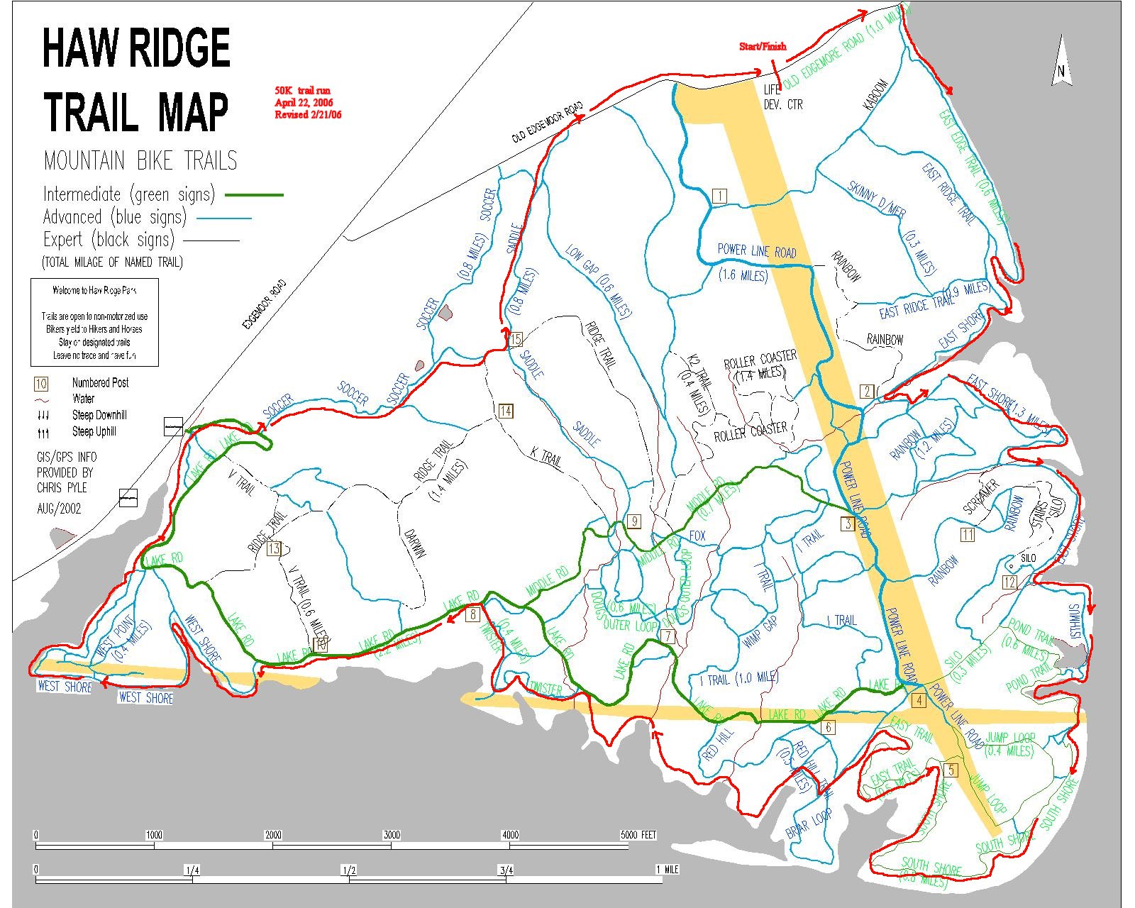
COURSE MAP Revised 2/21/06
The following course directions are "generally" the route that will be followed during the run. The course is marked with orange survey flags. Course directions and map will be provided to all runners prior to beginning the run. Note that unless indicated otherwise, the course proceeds around the perimeter of Haw Ridge Park in a clockwise direction, making left turns at intersections. Loop length is approximately 8.6 miles.
   Revised 2/21/06
Starting at the Life Development Center on Old Edgemoor Road:
Go east toward the lake on closed portion of Old Edgemoor Road 0.22m
Go RIGHT on East Edge Trail 0.95m
Go LEFT on East Short Trail 0.77m, talking LEFTs at all intersections
Go LEFT on Isthmus Trail (post 12) to Pond Trail 0.5m
Go LEFT on South Shore Trail 0.77m, gradually working around the peninsula
Go LEFT on Easy Trail (post 5) 0.48 m
At intersection with Briar Loop Trail, stay RIGHT and take next RIGHT
   on unmarked trail that crosses swampy area to Red Hill Trail
Veer LEFT as you enter swampy area, following faint unmarked trail. Follow
   this trail 0.3m to intersection with Red Hill Trail.  Look for
    water station at the lake edge,  blue jugs and orange Igloo coolers.
Go LEFT at intersection with Red Hill Trail, crossing over log bridge.  Follow
   this unmarked trail as it meanders.
Go left on Lake Road for 50 feet to intersection with Twister Trail.
Go LEFT on Twister Trail 0.4m
Go LEFT on Lake Road 0.4m
Go LEFT on West Shore Trail 0.85m, follow trail up inlet, then stay LEFT
   at switchback, continuing back down other side of inlet
Follow West Shore Trail to intersection with Lake Road
Go LEFT on Lake Road for 0.1m
Go LEFT on trail along water's edge 0.8m
Pass by wooden bridge and continue to Soccer Trail as you parallel new
  Edgemoor Road
Follow Soccer Trail to "barren area," then proceed to the RIGHT up a wide,
  low angle rocky area following the trail 0.2m to Ridge Trail
Go LEFT on Ridge Trail 0.1m
Go LEFT on Saddle Trail (post 15) 0.4m down to Old Edgemoor Road.
Go RIGHT on Old Edgemoor Road 0.34m to Life Development Center (end of loop)

REPORT TO AID WORKERS BEFORE CONTINUING ON AND/OR LEAVING THE EVENT.
| Directions to Life Development Center: |
From I-40 Take Pellissippi Parkway North toward Oak Ridge
through Solway and over Clinch River.
Take first exit on right after crossing river- Edgemoor Drive and
proceed for approx. 1 mile.
Turn right on old road (Old Edgemoor Road)
across from Centennial Golf Course and
proceed approx. 1 mile to Life Development Center on right.
See
Mapquest map.

Haw Ridge Park trail maps etc.