NOAA weather near waypoint
or
wunderground
NOAA weather near waypoint
or
wunderground
| WGS84 | |
| 36.432900 | -84.656700 |
| 36° 25.974'N | 84° 39.402'W |
| 36° 25' 58.4"N | 84° 39' 24.1"W |
| 16S 710053E 4034517N | |
| convert to NAD27 | |
MAPS
Select one of the following maps to display this waypoint (WGS84).
NOAA weather near waypoint
or
wunderground
GPS
Remarks:
Reference: Keith Garnes
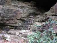
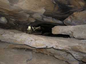
Along Honey Creek trail, climb the ladder to the rock house and
slither through the double arch to the adjoining rock house.