 NOAA weather near waypoint
or
wunderground
NOAA weather near waypoint
or
wunderground
| WGS84 | |
| 36.606400 | -84.546900 |
| 36° 36.384'N | 84° 32.814'W |
| 36° 36' 23"N | 84° 32' 48.8"W |
| 16S 719407E 4054012N | |
| convert to NAD27 | |
MAPS
Select one of the following maps to display this waypoint (WGS84).
NOAA weather near waypoint
or
wunderground
GPS
Remarks:
 Triangular shaped skylight in rockhouse just off-trail.
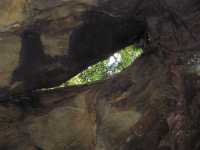 also a smaller skylight that's a small
waterfall in wet weather.
also a smaller skylight that's a small
waterfall in wet weather.