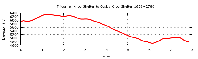
Based on the DEM data, elevation profiles between shelters have been created as part of the shelter data base. Below is an example. The plot has been smoothed, and even using a 10' filter the cumulative climb/descent numbers are probably 10% too high.
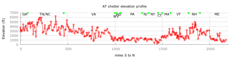
The highest point on the trail is near Clingman's Dome in TN (6615'), and the lowest point is in NY west of the Hudson River (119'). The steepest half-mile segment (38.4% grade) is heading North on Wildcat Ridge in NH starting at 44.24578 -71.25121. (Note, the MyTopo topo layer with the 2009 ATC track segment shows the track deviating from the dotted line on the topo?) The steepest mile (33.6% grade) is the descent off of Mount Blue in NH heading north starting at 44.03178 -71.81119
The table below shows the top 5 steepest half-mile and mile segments. To see the southern point of the north-bound segment, paste the lat,lon into the Find box of the AT Google map.
  Steepest half-miles               Steepest miles
    lat,lon         gradient     lat,lon         gradient
  44.24578,-71.25121  38%      44.03178,-71.81119  33%
  44.32034,-71.26115  37%      44.32115,-71.26116  30%
  44.03443,-71.80898  35%      45.89761,-68.96186  29%
  44.18750,-71.61102  33%      44.24604,-71.24960  29%
  44.18860,-71.56728  32%      44.11401,-71.65937  27%
Climb/descent from South to North
State    climb/descent (ft)
GA       20407/-20396
TN/NC    113904/-114476
VA       136323/-138409
WV        2455/-3299
MD        7296/-6358
PA       29960/-30857
NJ        7697/-7600
NY       22569/-22567
CT       12317/-10941
MA       18758/-18209
VT       34532/-36459
NH       53182/-50615
ME       67280/-6500
Total   526664/-525189
Use the zip file above to construct your own profile studies.
More AT elevation info
Visits since 9/13/11